Government recently revived the national airline, which our neo-liberalists had mistakenly appraised on commercial terms. Its main contribution is enhancement of competitiveness, by reducing the cost of air transport and easing connectivity since Uganda is a landlocked country.
Uganda Airlines will also support the harnessing of opportunities such as tourism and agriculture (horticulture, floriculture, fish and our nascent oil and gas). Therefore, the airline was revived primarily as infrastructure, as opposed to commercial business. We
revived it to reap from the economic multipliers and indirect dividends it will create.
Cognisant of this, the Government has also embarked on developing alternative airports
in addition to upgrading Entebbe International Airport.
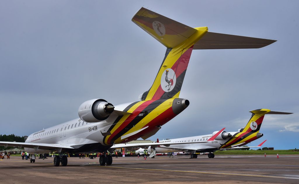
Uganda-airlines-bombardier
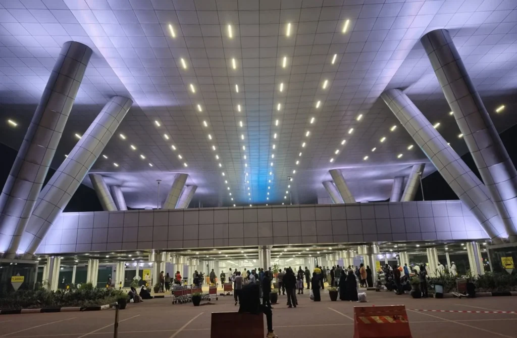
Entebbe International Airport – New terminal Side view
Soroti Airfield
Soroti Airport is an airport serving Soroti, a town in the Eastern Region of Uganda, approximately 290 kilometres (180 miles), by road, north-east of Kampala, Uganda’s capital and largest city. The main runway and apron are asphalt and can support aircraft up to the size of a Boeing 737, without damage to the surface.The airport is at an altitude of 3,697 feet (1,127 m), above sea level.
The airport was originally built as a school for the British Overseas Airways Corporation to train their pilots in tropical flying techniques. It was later used by the East African Civil Aviation Academy to train pilots from the East African Community.
As of June 2018, the airport is home to the Soroti Flying School, which has various aircraft, including a Cessna 310. The flying school provides training through instrument and multi-engine ratings. The flying school has dormitories, food service, and classrooms
Kasese Airfield.
The airport is located in the town of Kasese, Kasese District, in the Western Region of Uganda, at the foothills of the Rwenzori Mountains and close to the international border with the Democratic Republic of the Congo. It is approximately 261 kilometres (162 mi), by air, west of Entebbe International Airport, the country’s largest civilian and military airport.The coordinates of Kasese Airport are: 0°11’27.0″N, 30°06’10.0″E (Latitude:0.190825; Longitude:30.102786).
Kasese Airport is one of the 47 airports in the country. It is one of the twelve upcountry airports under the administration of the Civil Aviation Authority of Uganda (CAA). It is one of the five upcountry airports that are authorized to handle cross-border air traffic from member countries of the East African Community, as part of efforts to promote tourism within eastern Africa. Kasese Airport receives daily domestic flights from Murchison Falls National Park, Entebbe International Airport and Kajjansi Airfield, which are frequently used by tourists to visit Queen Elizabeth National Park.
The airport which sits at an altitude of 959 metres (3,146 ft), above sea level, has a single grass runway that measures 1,600 metres (5,249 ft) long and is 30 metres (98 ft) wide.
Pakuba Airfield
Pakuba Airfield is an airfield serving Pakuba and Murchison Falls National Park in the Nwoya District of northern Uganda.
The airport is operated by the Civil Aviation Authority of Uganda. It is one of the five upcountry airports that are authorized to handle cross-border air traffic from member countries of the East African Community, as part of efforts to promote tourism within eastern Africa. Pakuba Airfield receives daily domestic flights from Entebbe International Airport and Kajjansi Airfield, which are primarily used by tourists to visit Murchison Falls National Park, as well as connecting to Kidepo Valley National Park and Queen Elizabeth National Park.
Pakuba Airfield is approximately 275 kilometres (171 mi) by air north-west of Entebbe International Airport, the country’s largest civilian and military airport.
It is 15 kilometres (9 mi) north-west of Bugungu Airstrip and 72 kilometres (45 mi) west of Chobe Safari Lodge Airport, which are also within Murchison Falls National Park.
Moyo Airfield
Moyo Airport is located in the town of Moyo, Moyo District, West Nile sub-region, in Northern Uganda, close to the International border with South Sudan. Its location is approximately 406 kilometres (252 mi), by air, north of Entebbe International Airport, the country’s largest civilian and military airport. The geographic coordinates of this airport are 3°38′56″N31°45′52″ECoordinates: 3°38′56″N31°45′52″E.
Moyo Airport is a small civilian airport that serves the town of Moyo. As of August 2011, the airport is not yet under the administration of the Uganda Civil Aviation Authority. Moyo Airport is situated 3,100 feet (940 m) above sea level. The airport has a single unpaved runway which measures 4,260 feet (1,300 m) long.
Kajjansi Airfield
The airfield is approximately 29 kilometres (18 mi), by road, north-east of Entebbe International Airport, Uganda’s largest airport, and 17 kilometres (11 mi) south of the central business district of Kampala, Uganda’s capital and largest city. The geographical location of the airfield are:0°12’01.0″N, 32°33’00.0″E (Latitude:0.200278; Longitude:32.550000). Kajjansi Airfield sits at an elevation of 1,141 metres (3,743 ft) above mean sea level. Kajjansi is located in the southern portion of the Kampala conurbation. The airport has one unpaved runway 14/32, which is 1,150 metres (3,773 ft) long. The runway is east of the Kampala–Entebbe Road, bordering marshland near the shore of Lake Victoria.
Ownership
The airfield is owned and operated by Mission Aviation Fellowship (MAF), an international Christian humanitarian relief and development organisation. In the mid-2010s, the Christian engineering charity Engineering Ministries International (EMI) redeveloped the office building of the airfield. The new office building became the headquarters of both MAF Uganda and EMI East Africa.
Operations
Kajjansi Airfield is also the operations base for Kampala Aeroclub and Flight Training Centre (KAFTC). The company operates scheduled and charter tours to three of Uganda’s national parks; Murchison Falls National Park, Queen Elizabeth National Park and Bwindi National Park.
The same company maintains an ICAO-recognized flight-training school that trains, tests and awards private pilots licenses. The school is sometimes referred to as kanjansi flying school. KAFTC also operates an aircraft maintenance facility at this airport, under the name of Kampala Aero Maintenance.
Kabaale International Airport
is an airport under construction in Hoima, Uganda. It is part of the infrastructure under construction as Uganda prepares to develop its nascent petroleum industry. When completed, it would be Uganda’s second international airport, besides Entebbe International Airport. The new airport is expected to facilitate mobilization of equipment for construction of the Uganda Oil Refinery and assist in the development of agriculture and tourism in Uganda’s Western Region.
Location
Hoima Airport is located in Kabaale Parish, Buseruka sub-county, Hoima District in the Western Region of Uganda, near the Kaiso-Tonya oil fields and the Uganda Oil Refinery. The air distance between the general area where the airport is being built and Entebbe International Airport, Uganda’s largest civilian and military airport, is about 200 kilometres (124 mi). Kabaale International Airport sits on 29 square kilometres (11 sq mi). The location of Hoima International Airport is approximately 51 kilometres (32 mi), by road, to the west of the city of Hoima.The elevation of Kabaale Village is 1,070 metres (3,510 ft), above mean sea level.