
Share
Achwa Hydroelectric Power Station
The Achwa 1 Hydroelectric Power Station (A1HPS), also Achwa I Hydroelectric Power Station, is a hydroelectric power station in Uganda, with a planned installed capacity of 41 megawatts (55,000 hp). The facility is located across the Achwa River, in Gulu District, Northern Uganda. This location is at the border between Gulu District and Pader District, approximately 38 kilometres (24 mi) north of the settlement of Aswa. This location is within close proximity of the Achwa 2 Hydroelectric Power Station. This is approximately 65 kilometres (40 mi), by road, northeast of Gulu, the largest city in Northern Uganda. Achwa 1 is a run-of-the-river hydroelectricity project with planned annual output of 274 GWh. This power station is one in a cascade of five power stations planned on the Achwa River totaling 109 megawatts (146,000 hp). The power generated will be sold to the Uganda Electricity Transmission Company Limited, for integration into the national electricity grid. The power generated will be evacuated via the Lira–Gulu–Agago High Voltage Power Line, a 132kV high voltage transmission line, to a substation in Lira, a distance of approximately 140 kilometres (87 mi), where it will be sold to the Uganda Electricity Transmission Company Limited (“UETCL”). Other infrastructure that will be constructed include 9 kilometres (6 mi) of service roads, a 38 kilometres (24 mi) service road to connect the site to the Gulu-Kitgum Road and a camp for the construction workers. In 2016, solicitation for bids to carry out feasibility and environmental impact assessments for this power station, were advertised. The development rights are owned by Berkeley Energy, through its wholly owned Ugandan subsidiary, Maji Power Limited. Works were ongoing as of January 2020.
Bugoye Power Station
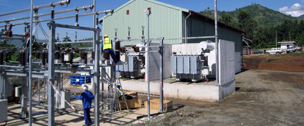
Bugoye Power Station is a 13 MW (17,000 hp) mini hydroelectric power station in Uganda. In the literature, Bugoye Power Station is sometimes referred to as Mubuku II Power Station. The power station is located across the Mubuku River, in Bugoye, Kasese District, in Western Uganda. This location lies in the foothills of the Rwenzori Mountains, close to the border with the Democratic Republic of the Congo. Bugoye lies approximately 19 kilometres (12 mi), by road, north of Kasese, the location of the district headquarters, and the nearest large city. The Bugoye Hydropower Project, is a run of the river mini-hydropower installation, with installed capacity of 13 MW. The energy generated is fed into the national electric grid at Nkenda Substation, located 6 kilometres (3.7 mi) from Bugoye, via a 33kV transmission line. The power station is owned and operated by TronderEnergi, a Norwegian power company. Construction began in March 2008 and the plant was commissioned 19 months later in October 2009. Bugoye Power Station is the third mini-hydropower station on River Mubuku. The other two are Mubuku I Power Station, owned by Kilembe Mines Limited (KML), with installed capacity of 5 MW and Mubuku III Power Station, owned by Kasese Cobalt Company Limited (KCCL), with installed capacity of 10 MW. The estimated costs for the dam and power plant is approximately US$35 million. The funding was facilitated by a loan from the Emerging Africa Infrastructure Fund, (EAIF). This does not include the construction of a 33kV transmission power line linking the power station to the substation where the power is integrated into the national grid. The power line was funded by a grant from the Government of Norway to the Government of Uganda. By mutual consent between the two governments, Tronder Power Limited, assumed the responsibility of developing, constructing, maintaining and servicing the power line. Tronder Power Limited is a Ugandan company co-owned by TronderEnergi and Norfund.
Bujagali Power Station
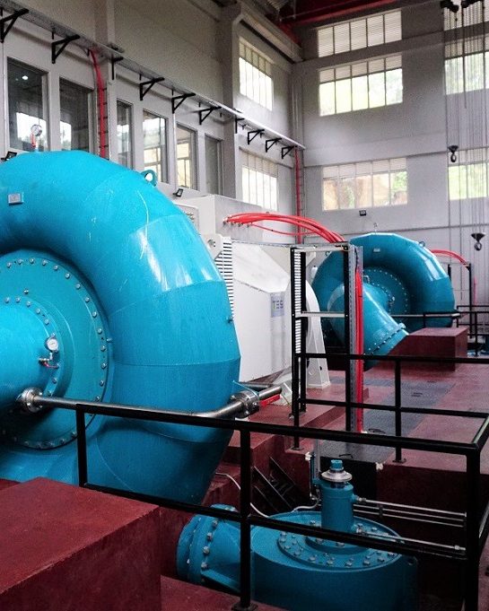
The Bujagali Power Station is a hydroelectric power station across the Victoria Nile that harnesses the energy of its namesake; the Bujagali Falls, in Uganda. Construction began in 2007 and concluded in 2012. It was officially inaugurated on 8 October 2012 by Ugandan President Yoweri Museveni and Aga Khan IV in the presence of African politicians and investors. The capacity of the power station is 250 megawatts. The station was the largest hydroelectric energy source in Uganda, at the time it was commissioned. However, the planned Karuma and Ayago power stations would be larger. The funding for the station was a source of some concern, as investors joined and departed from the project. As of July 2014, the plant was managed by Bujagali Energy Limited, which selected Italian contractor Salini Impregilo to develop the project. The power station lies across the Victoria Nile, about 15.5 kilometres (10 mi) north-west of the central business district of the city of Jinja and immediately north of the former location of the Bujagali Falls. It is at the border between Buikwe District to the west and Jinja District to the east. The coordinates of Bujagali Power Station are 0° 29’54.00″N, 33° 08′ 15.00″E (latitude:0.498325; longitude:33.137500). As far back as 2001, the government of Uganda started to plan the construction of a hydroelectric power plant at Bujagali Falls. The original developers included AES Energy from the United States and the Madhvani Group from Uganda. In the midst of fraud investigations, the first project was abandoned in 2003 when AES Energy pulled out of the deal, citing a protracted process because of objections from environmentalists. The project was delayed due to protracted negotiations between investors and representatives of the Soga cult of the water spirit Budhagaali, whose main shrines were seen as inextricably linked to the strength of the waterfall. Ultimately agreement was reached between the parties. A new consortium, Bujagali Energy Limited, was created by Sithe Global Power LLC, from the United States, and Industrial Promotion Services, a division of the Aga Khan Fund for Economic Development, and was tasked with developing the project. Construction of the dam and powerhouse started in June 2007. Salini Impregilo was selected to be the lead contractor. The power station began commercial operations on 1 August 2012. At the peak of construction activity, the project employed over 2,500 people, including about 2,200 Ugandan nationals.
Kabalega Hydroelectric Power Station
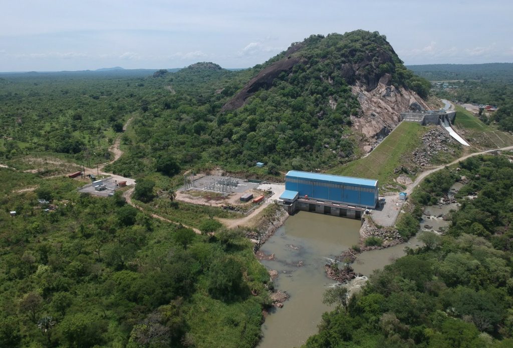
Kabalega Hydroelectric Power Station, also known as Kabalega Power Station is a 9 MW (12,000 hp) mini hydroelectric power project located across River Wambabya, in Buseruka Sub County, Hoima District, in Western Uganda. At the beginning of planning and during construction, the power station was referred to as Buseruka Power Station, but was renamed after completion. The power station is located in Buseruka Village, close to the eastern shores of Lake Albert. Buseruka is located approximately 37 kilometres (23 mi), by road, west of Hoima.
The initial estimated cost for the dam and power plant was approximately US$30 million. As time went on, that estimate was increased to US$36 million. The dam, power plant and 44 kilometres (27 mi) of high voltage transmission line from the power house to Kinubi Power Substation in Hoima, are being constructed by Hydromax, a private energy investor. Funding for the project is facilitated by loans from the African Development Bank (US$9 million) and from the PTA Bank (US$10 million).
Construction, which started in 2005, was completed in January 2013 and was commissioned by the president of Uganda, Yoweri Museveni, on 26 January 2013. At that time, the high voltage line which will evacuate the power generated to a substation that will integrate into the national grid, was yet to be completed.
Kanungu Power Station
Kanungu Power Station is a 6.6 megawatts (8,900 hp) run-of-the-river hydroelectric power station on the Ishasha River in Uganda.
The station is sometimes referred to as the Ishasha Power Station.
Location
The power station is in the Kanyantorogo sub-county of Kanungu District in southwestern Uganda, about 34 kilometres (21 mi) by road from the district headquarters in the town of Kanungu, although the straight air distance is only about 12 kilometres (7 mi). The geographical coordinates of the power station are: 0°52’53.0″S, 29°40’14.0″E (Latitude:-0.881389; Longitude:29.670556).
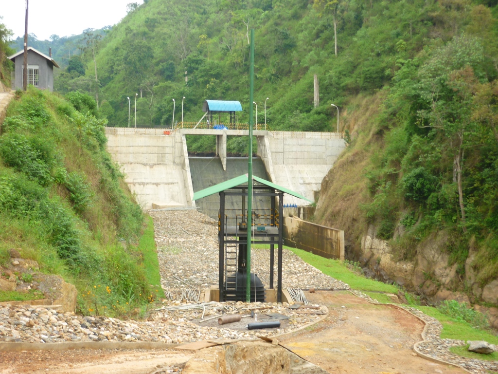
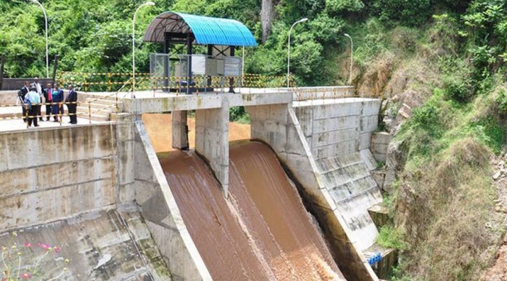
The dam and weir on the Ishasha River are 500 metres (1,600 ft) downstream from the boundary of the Bwindi Impenetrable National Park. A 1,140 metres (3,740 ft) penstock takes water downstream to the twin-Francis turbine power station, for a rated head of 91 metres (299 ft). A tailrace then takes water from the power station and returns it to the Ishasha River. Provision has been made for an open-pipe flow of 250 liters per second into the section of the river between the dam and the tailrace to ensure that local fish species are not adversely affected. A 7 kilometres (4.3 mi), 33 kiloVolt transmission line connects the power station to the national grid.
History
The power station was constructed by Eco Power Uganda Limited, a subsidiary of Eco Power Holdings Limited of Sri Lanka. Construction was completed in March 2011.The power plant was technically commissioned on 18 March 2011. Political commissioning was performed on 22 November 2011. The plant is expected to support development of industries and stimulate other areas of investment in Kanungu and the surrounding rural areas, including parts of the neighboring Democratic Republic of the Congo.
Kiira Hydroelectric Power Station
Kiira Hydroelectric Power Station, is a hydroelectric power station in Uganda, with an installed capacity of 200 megawatts (270,000 hp).
Location
The power station is located at Kimaka, a northern suburb of Jinja, in Jinja District, in the Eastern Region of Uganda, approximately 5.5 kilometres (3 mi) northwest of the central business district of the city of Jinja. Kiira Power Station operates next to the Nalubaale Power Station at the point where the River Nile pours out of Lake Victoria starting its 6,650 kilometres (4,130 mi) journey to the Mediterranean Sea. The coordinates of Kiira Hydroelectric Power Station are: 0°27’01.0″N, 33°11’08.0″E (Latitude:0.450272; Longitude:33.185558).
History
In 1993, work started on the Nalubaale Power Station extension project. The new project is a second powerhouse located about 1 kilometre (0.62 mi) northeast of the Nalubaale Power Station, which was built in 1954. A new canal was cut to bring water from Lake Victoria to the new powerhouse. Major construction was completed in 1999. The first power from two units out of the installed five units, came online in 2000. As of 2003, three of the five hydro power generators had been installed. Installation of the fifth and final turbine was completed in January 2007. Each unit at the extension has a capacity of 40 megawatts. During official opening ceremonies in 2003, the extension was named the “Kiira Power Station”. Design and project management of the extension project was by Acres International (now part of Hatch Ltd), Canada.
Mpanga Power Station
Mpanga Power Station is an 18 megawatts (24,000 hp) mini hydroelectric power project located across River Mpanga, in Kitagwenda County, Kitagwenda District in Western Uganda.
Location
The power station is located across River Mpanga, in Kitagwenda County, Kitagwenda District where the district headquarters are located, approximately 25 kilometres (16 mi), by road, southwest of Kamwenge. This location is approximately 305 kilometres (190 mi), by road, west of Kampala, Uganda’s capital and largest city.
Overview
Mpanga Power Station is situated at the location of Mpanga Falls, on Mpanga River. The 18.0 MW power station was developed by Africa Energy Management Systems. Construction began in 2007. The completed power station came online in 2011. A new 33kV transmission line connects the power station to the national electrical grid. As of February 2011, construction of the power station was complete. Technical commissioning was scheduled for Thursday 10 February 2011, while the public commissioning was planned for March 2011. Construction of the power station was undertaken by a Sri Lankan hydropower construction company called VS Hydro (Private) Limited, at an estimated cost of US$26 million. Mpanga Hydro Power is owned by “EMS Africa” and all the engineering tasks including Operations and Maintenance is done by Sri Lankan Engineers. There are 32 staff (Both Ugandan and Sri Lankan) members currently employed at the site to do the day-to-day operation of the plant. Annual expected generation of the plant is 64 gigawatt-hours (230 TJ).

Mubuku I Power Station
Mubuku I Power Station is a 5 megawatts (6,700 hp) mini-hydroelectric power station in Uganda.
Location
The power station is located between Bugoye and Kitoko, straddling the Mubuku River in Kasese District in Western Uganda. The station is in the foothills of the Rwenzori Mountains, close to the border with the Democratic Republic of the Congo. Kitoko lies approximately 20 kilometres (12 mi), by road, north of Kasese, the location of the district headquarters and the nearest large city.
History
Kilembe Mines Limited built the state in the 1950s to power the extraction of copper ore from the Rwenzori Mountains. The copper extraction ceased in the 1970s, and the power generated is now sold to the national grid. The Mubuku I Power Station is the third mini-hydropower station on the Mubuku River. The other two are the Mubuku II Power Station, commonly known as the Bugoye Power Station and owned by Tronder Power Limited, a Norwegian company, and the Mubuku III Power Station, owned by Kasese Cobalt Company Limited with an installed capacity of 10 megawatts (13,000 hp).
Overview
The station is a run-of-the-river mini-hydropower installation, with installed capacity of 5 megawatts. In September 2013, Ugandan print media indicated that the Tibet-Hima Consortium, the Chinese company that won the concession to run Kilembe Mines for the next twenty five years, has plans to increase capacity of the power plant to 12 megawatts. The concession agreement was later terminated in September 2017 following reports of failure by Tibet-Hima to meet obligations stipulated in the agreement.
Mubuku III Power Station
Mubuku III Power Station is a 10 megawatts (13,000 hp) mini-hydroelectric power station in Uganda.
Location
The power station is located across the Mubuku River, near the town of Mubuku, Kasese District, in Western Uganda. This location lies in the foothills of the Rwenzori Mountains, close to the border with the Democratic Republic of the Congo. Mubuku lies approximately 17 kilometres (11 mi), by road, north of Kasese, the location of the district headquarters, and the nearest large city.
Overview
The Mubuku III Power Station, is a run of the river mini-hydropower installation, with installed capacity of 10 MW. It became operational in 2008, having been built by Kasese Cobalt Company Limited, a company that extracts cobalt from the sludge left when copper is extracted out of copper ore. The excess power generated is sold to the national grid. Mubuku III Power Station is the third mini-hydropower station on River Mubuku. The other two are Mubuku I Power Station, owned and operated by Kilembe Mines Limited, with installed capacity of 5 MW and Mubuku II Power Station, also known as Bugoye Power Station, with capacity of 13 MW, owned by Tronder Power Limited, a Norwegian company.
Nalubaale Power Station
Nalubaale Power Station, formerly known as Owen Falls Dam, is a hydroelectric power station across the White Nile near its source at Lake Victoria in Uganda. Nalubaale is the Luganda name for Lake Victoria.
Location
The dam sits across the Nile River between the town of Jinja, in Jinja District and the town of Njeru in Buikwe District, approximately 85 kilometres (53 mi), by road, east of Kampala, Uganda’s capital and largest city.
History
Before the construction of the dam, water levels on Lake Victoria were moderated by a natural rock dam on the north side of the lake. Rising lake waters would spill over the natural dam into the White Nile, which flows through Uganda, South Sudan, Sudan, and Egypt before emptying into the Mediterranean Sea. When water levels dropped too low, flow into the river ceased. In 1947, Charles Redvers Westlake, an English engineer, reported to the Colonial Government of Uganda recommending the construction of a hydroelectric dam at Owen Falls near the city of Jinja. This led to the establishment of the Uganda Electricity Board (UEB), with Westlake as its first chairman. A treaty between Uganda and Egypt ensured that the natural flow of the Nile would not be altered by the dam. The consultant engineer on the project was Sir Alexander Gibb & Partners. Eighty thousand tons of plant and construction materials (including 36,000 tons of cement) were shipped out from Europe in the difficult post-war period. They were then hauled 1,200 kilometres (750 mi) by rail from Mombasa to Jinja. The dam was completed in three years, ahead of schedule in 1954, submerging Ripon Falls. It supplies electricity to Uganda and parts of neighbouring Kenya and Tanzania. Maintenance and availability of the station declined seriously during the government of Idi Amin. The rating of the Nalubaale power station is 180 megawatts (MW). Originally it was designed for ten turbines rated at 15 MW each (for a total of 150 MW. The station was refurbished in the 1990s to repair the accumulated wear from a decade of civil disorder. During the repairs, the output power of the generators was increased, bringing the Nalubaale Power Complex’s generating capacity to 180 MW.

Nyamagasani I Hydroelectric Power Station
Nyamagasani I Hydroelectric Power Station, also Nyamagasani 1 Hydroelectric Power Station is a 15 megawatts (20,000 hp) hydroelectric power project, under construction in Uganda.
Location
The power station is located near the village of Kyarumba, in Kasese District, approximately 45.3 kilometres (28 mi), by road, south-west of Kasese, the nearest large town.
Overview
Nyamagasani I Hydroelectric Power Station is a run-of-river hydro-power plant, with initial planned capacity installation of 15 megawatts (20,115 hp), when completed. The project lies across the Nyamagasani River, adjacent to its sister project, Nyamagasani II Hydroelectric Power Station, high in the foothills of the Rwenzori Mountains, at an average elevation of about 1,392 metres (4,567 ft). The project company, Rwenzori Hydro Private Limited, is majority-owned by DI Frontier Market Energy & Carbon Fund, a Denmark-based renewable energy investment company.

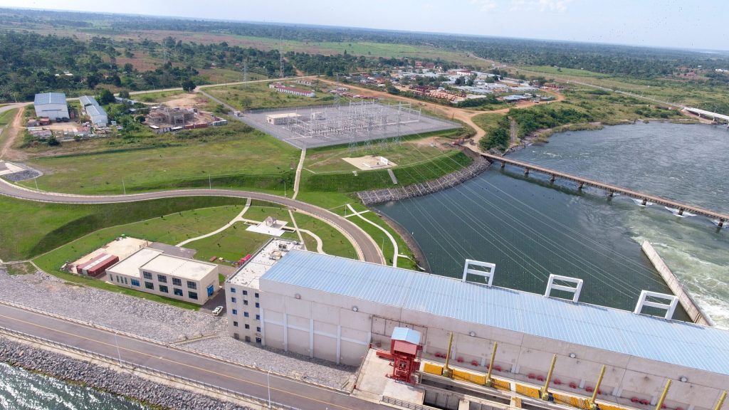
Isimba Hydroelectric Power Station
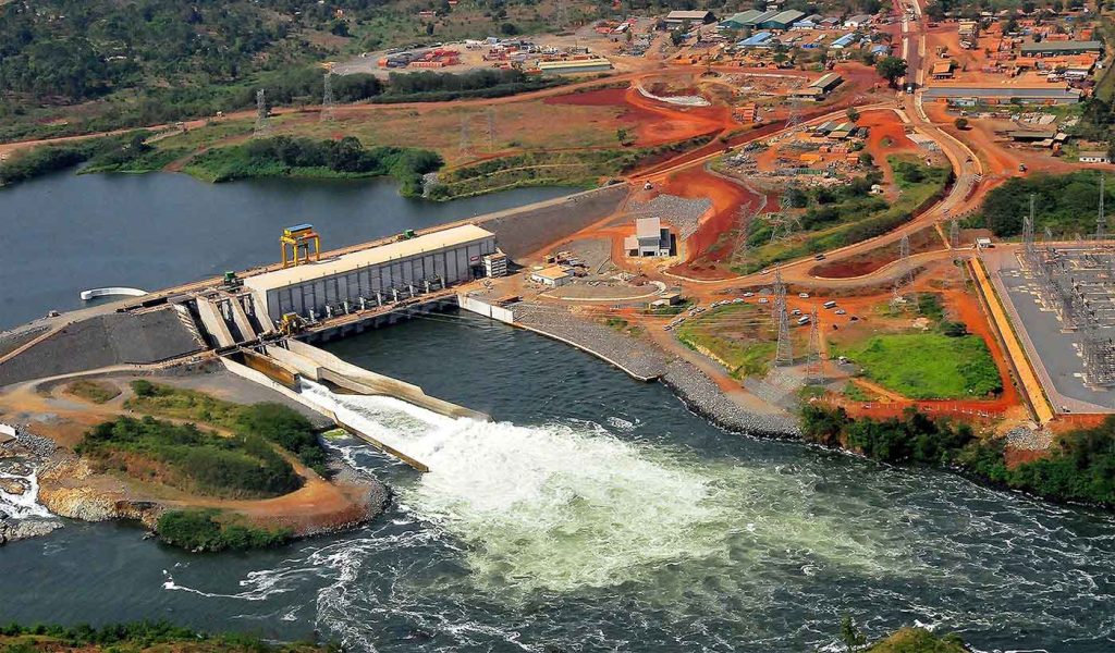
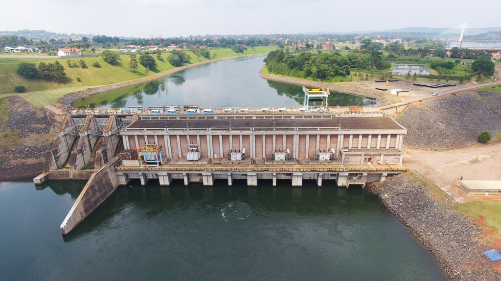
Isimba Hydroelectric Power Station is a 183.2 megawatts (245,700 hp) hydroelectric power station commissioned on 21 March 2019 in Uganda. Construction of this dam began in April 2015 and was completed in January 2019. Commercial operations began on 21 March 2019.
Location
The power station is located at the village of Isimba on the Victoria Nile, in Kamuli District. This is approximately 44 kilometres (27 mi), by road, north of the Bujagali Hydroelectric Power Station. The geographical coordinates of Isimba Power Station are: 00°46’18.0″N, 33°02’32.0″E (Latitude:0.771667; Longitude:33.042222).
Kikagati Hydroelectric Power Station
Kikagati Hydroelectric Power Station, also referred to as Kikagati Power Station, is a 15.57 MW (20,880 hp) hydroelectric power station, in Uganda.
Location
The power station is located across the Kagera River, along Uganda’s International border with the United Republic of Tanzania. This location lies near the town of Kikagati, approximately 63.5 kilometres (39.5 mi), by road, south of Mbarara, the largest city in the sub-region. Kikagati lies approximately 331 kilometres (206 mi), by road, southwest of Kampala, the capital of Uganda and the largest city in that country. The geographical coordinates of the power station are 01°03’27.0″S, 30°39’33.0″E (Latitude:-1.057500; Longitude:30.659167).
Overview
Kikagati Power Station is a mini-hydropower plant, with initial planned capacity installation of 10 MW (13,000 hp), when completed. The project will involve the construction of a dam, creating a 4,000 square metres (0.99 acres) reservoir lake. The new reservoir will lie partly or wholly, within Tanzania. The new power station will be built at the location of another smaller power station that was destroyed in 1979 during the war that removed Idi Amin from power in Uganda.
In September 2011, the planned capacity installation was increased to 16.5 MW. This power project received partial funding from the Uganda GetFit Program.
Between 2008 and 2013, the Chinese pulled out of the deal. Development rights were taken up by TrønderEnergi, a Norwegian power company, with a Ugandan subsidiary Tronder Energy Limited. In July 2013, TronderEnergi advertised for suitable firms to bid on the construction of Kikagati Power Station. Bids were also sought on the nearby Nshungyezi Hydropower Station, a proposed 39 MW (52,000 hp) minihydroplant, approximately 13 kilometres (8.1 mi), downstream of Kikagati, on which TronderEnergi has development rights as well.
In January 2022, Voith Hydro completed the installation of three turbines, each rated at 5.19 MW, for total generation capacity of 15.57 MW, to be sold directly to the Uganda Electricity Transmission Company Limited (UETCL), via a 33kV evacuation line. UETCL, will in turn, sell half of the power station’s energy to Tanzania Electric Supply Company Limited (TANESCO). The total construction cost was reported as US$87 million. A 33kV medium voltage evacuation line transmits the generated energy to a point where it enters the Ugandan electricity grid.
